Category: Driving

  • Driving from Melbourne to Adelaide

    When you fly somewhere, it’s all about getting to your destination as quickly as possible. You step on a plane at one end and leave the plane at the other end. Whereas when you drive to your destination, you get to see and experience what is along the way, and maybe even take a detour or two.

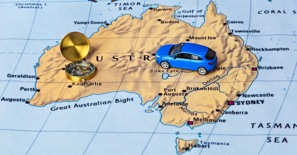
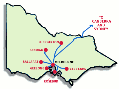
    When driving between Melbourne and Adelaide, there are a quite a few route options available, however we will cover three here – the most direct, along the coast and the route up north.

    3 different driving routes from Melbourne to Adelaide.

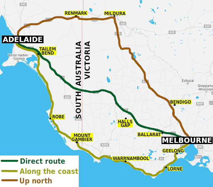
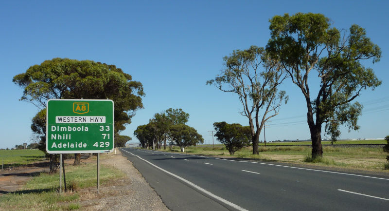
    1. Direct route – Western Highway & Dukes Highway

    Western Highway.

    The inland route is the quickest and shortest, thus it is also used by road transport operators moving goods between Melbourne and Adelaide.

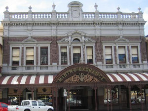
    Follow the Western Freeway out of Melbourne, and maybe get off the freeway and visit Ballarat – Victoria’s third largest city which has a rich history dating back to its prosperous days during the Gold Rush era.

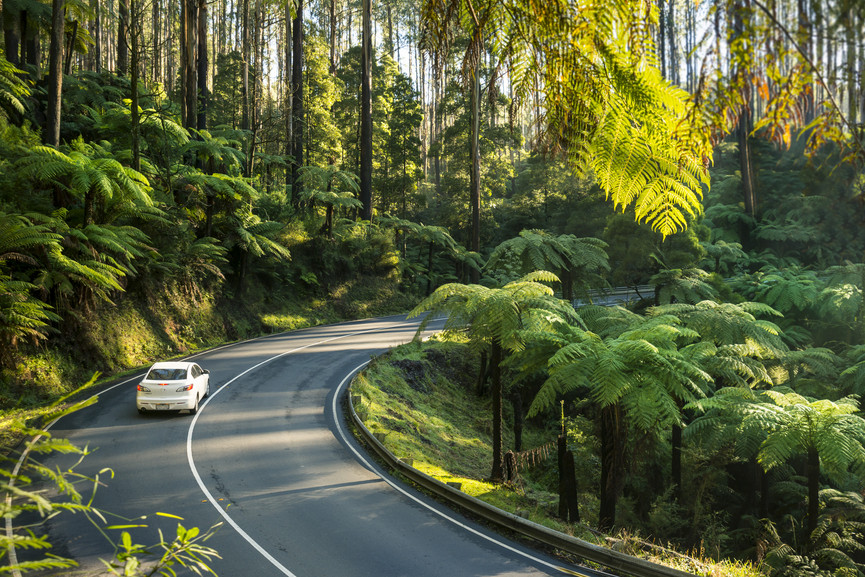
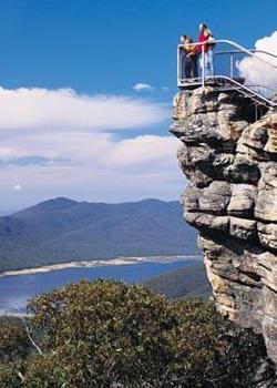
    Nature lovers will want to turn off the Western Highway at Ararat and detour to Halls Gap which lies within the famous Grampians National Park. There are waterfalls to discover, challenging hiking trails, stunning mountain views, lots of native wildlife and rich Aboriginal heritage that dates back many thousands of years.

    Approximately 440 kilometres from Melbourne, the Western Highway crosses the state border into South Australia and the road becomes known as the Dukes Highway.

    Follow the Dukes Highway to Tailem Bend – an attractive road junction town which overlooks the lower reaches of the mighty Murray River.

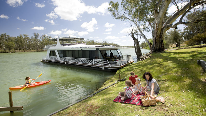
    Follow the Princes Highway to Murray Bridge – also set on the Murray River and home to a large fleet of houseboats.

    A 75 kilometre drive along the South Eastern Freeway will then take you into Adelaide, concluding the 726 kilometre road trip.

    2. Along the coast – Great Ocean Road

    Great Ocean Road.

    Water lovers with time to spare should take the coastal route to Adelaide. It adds about 300 kilometres to the journey and significantly extra time due to some section of windy roads and passing through many coastal towns.

    Follow the Princes Freeway out of Melbourne to Victoria’s second largest city of Geelong, which overlooks Corio Bay. From there, head south to Torquay which is the official start of the internationally recognised Great Ocean Road.

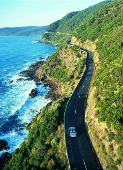
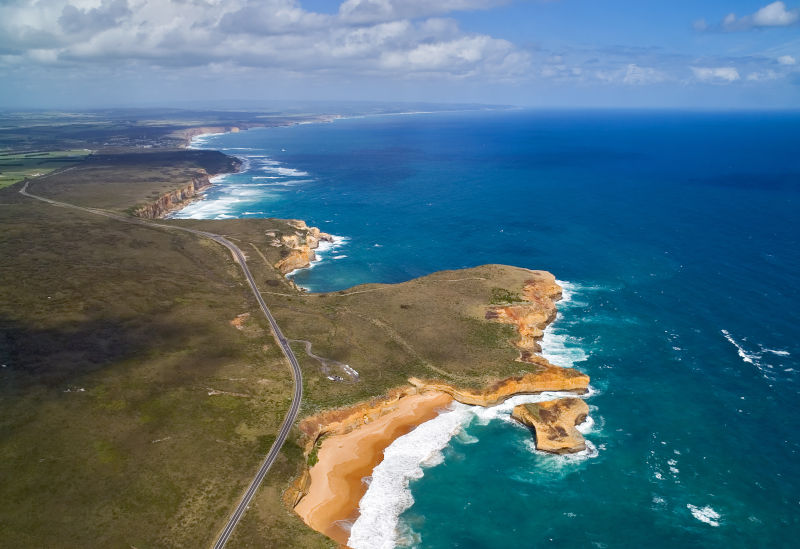
    The Great Ocean Road is a spectacular coastal drive where you can enjoy panoramic coastal scenery, see stunning rock formations such as the 12 Apostles, explore lush rainforests and visit seaside communities which welcome travellers and holidaymakers.

    The Great Ocean Road ends at the city of Warrnambool. Head west along the Princes Highway to the historic fishing village of Port Fairy and onto the deep sea port of Portland which was the site of Victoria’s first permanent settlement. Leave the highway at Portland and follow Portland – Nelson Road to the town of Nelson – a small village set on the majestic Glenelg River, within a stone’s throw of the state border with South Australia.

    Follow Glenelg River Road across the border and to the large regional city of Mount Gambier. This geological hotspot is famous for its Blue Lake and stunning sinkholes. Take a 28 kilometre detour down to the coast to Port MacDonnell – once a busy shipping port, but now a quiet and charming village.

    After leaving Mount Gambier, turn off the Princes Highway at Millicent and travel along the Southern Ports Highway to explore the coastal holiday towns along South Australia’s Limestone Coast. Check out Beachport, the ever popular holiday town of Robe and also Kingston SE with its Big Lobster.

    Rejoining the Princes Highway, the coastal route traverses the Coorong National Park – internationally recognised wetlands with salty lagoons and gorgeous sandy beaches. Pass through Meningie, which is set on the shores of Lake Albert, before reaching the Murray River at Tailem Bend and completing the final leg of the journey to Adelaide.

    3. Up north – Calder Highway & Sturt Highway

    Murray River at Mildura.

    In complete contrast to the coastal route, the northern route traverses the more remote parts of Victoria and South Australia, adding around 200 kilometres to the journey.

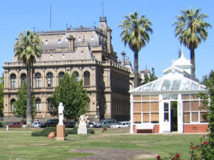
    Follow the Calder Freeway out of Melbourne and through the Macedon Ranges to Bendigo. Like Ballarat, this city thrived during Victoria’s Gold Rush days, leaving a lasting legacy of opulence and wealth.

    Heading out of Bendigo on the Calder Highway takes you through a number of rural communities and through Victoria’s vast Mallee region which is home to huge farms that grow grain and other crops.

    The Calder Highway ends in the far north-west corner of Victoria at the city of Mildura. Set on the Murray River and one of the warmest spots in the state, Mildura is a popular holiday destination, particularly for those who enjoy water activities on the river, and it is surrounded by vast wineries and fruit farms.

    From Mildura, head west along the Sturt Highway, across the state border into South Australia, arriving at Renmark. Renmark is the gateway to South Australia’s Riverland region, with its Mediterranean climate creating a rich fruit growing area with irrigation provided by the Murray River. Visit the attractive river-front towns of Berri, Loxton and Waikerie.

    The Sturt Highway continues west and passes through the northern section of the Barossa Valley at Nuriootpa. The Barossa Valley is, of course, one of Australia’s most famous wine region where you will find the biggest names in the wine industry.

    From Nuriootpa, it is a 72 kilometre drive to Adelaide, however you may want to take the more scenic route along Barossa Valley Way through the charming grape growing towns of Tanunda and Lyndoch.

  • Plan your Aussie getaway after the coronavirus pandemic

    Plan your Aussie getaway after the coronavirus pandemic

    Australians are living through a period unknown to most – a period where things we take for granted are restricted or no longer permitted. Travel across some state borders is regulated, cafes and restaurants can no longer serve dine-in customers, many attractions are closed, events are postponed and entertainment severely limited. Our leisure activities have been heavily curtailed as part of necessary efforts to contain the spread of the coronavirus (COVID-19) pandemic.

    The traditional Easter and school holiday activities, where people get in the car for a road trip or board a plane for a distant destination, are on hold, with people told to instead stay at home this Easter.

    Like all pandemics, coronavirus will not last forever. That means lovers of travel can use this time to plan their next getaway when travel restrictions are lifted.

    With many communities across Australia having been badly affected by recent drought and bushfires, and now battling the economic shock of the coronavirus shutdown, these communities will be crying out for visitors once things get back to normal. Of course, it is not just communities that service travellers as they criss-cross the country along highways and byways that have been badly affected – also Australia’s major cities and world-class tourist attractions have been impacted.

    Support Australian tourism, so once the coronavirus restrictions are over, you can plan your next getaway within Australia rather than dashing overseas.

    There is no better way to see Australia than with a road trip.

    Travel Tracks Australia (also on Instagram @traveltracksaus) is launching their Aussie Road Trip Itineraries ebook, which is packed with 37 road trips from all over Australia. There are 5 trips in Victoria – Great Ocean Road, Great Ocean Walk, Grampians, Phillip Island and Yarra Ranges. Get inspiration to start planning your next getaway when restrictions ease up.

    The Aussie Road Trip Itineraries ebook is now completely free to readers of this blog when you enter in the discount code of TRAVELVICTORIA at the check-out. Get the ebook for free now.

    Start reading today and plan your next getaway around our great country!

  • How to get to Wilsons Promontory from Melbourne

    Wilsons Promontory

    Wilsons Promontory is a peninsula at the southernmost tip of of Victoria that is surrounded by water on three sides and extends into Bass Strait.

    The Wilsons Promontory National Park covers around 50,000 hectares of this peninsula, consisting of stunning granite mountain peaks, beautiful beaches, lakes, forests and gullies.  It is home to a large population of wildlife including kangaroos, emus, echidnas, wombats and birdlife.

    Within the national park is the small town of Tidal River which has a visitor centre, general store and cafe.

    In order to get to Wilsons Promontory, there are a number of transport options available.

    By car

    One of the best ways of getting to Wilsons Promontory is to drive, so you have the flexibility of stopping at a number of interesting spots along the way.

    The driving distance from Melbourne’s CBD to the Wilsons Promontory town of Tidal River is just over 220 kilometres.

    Follow the Monash Freeway (M1) away from the city.  In order to get to the South Gippsland Highway, you can either take the South Gippsland Freeway (M420) exit, the Clyde Road (C407) exit, the Cardinia Road exit or the Koo Wee Rup Road (C422) exit.  All of those roads will eventually meet the South Gippsland Highway (M420) where you will need to turn left.  Follow the highway past the turn-off for Lang Lang until you reach the exit labelled Korumburra, Leongatha and Wilsons Promontory.  You will need to take this exit to remain on the South Gippsland Highway (A440), otherwise you will find yourself on the Bass Highway heading towards Phillip Island and Wonthaggi.

    Stay on the South Gippsland Highway as you pass through the towns of Korumburra, Leongatha and Meeniyan.  On the outskirts of Meeniyan, turn right onto Meeniyan-Promontory Road (C444) and follow this to Fish Creek where you will need to make a right turn in order to stay on the Meeniyan-Promontory Road (C444).  This road passes through Yanakie, which is located 6 kilometres from the entrance to Wilsons Promontory National Park.  Once inside the park, it is a further 25 minutes drive to Tidal River.

    The entire journey normally takes around 2 hours and 50 minutes if driving non-stop, although it is recommended to take at least a short break due to the duration of the trip.

    Driving directions from Melbourne to Wilsons Promontory

    By public transport

    The first step is to catch a bus to Fish Creek.  There is a V/Line bus service which runs between Southern Cross Station in Melbourne and Yarram, stopping at Fish Creek in front of the Fish Creek Hotel and BP service station.  This bus service runs 7 days a week, with extra services on weekdays.  See the V/Line bus timetable to Yarram via Fish Creek.

    Once in Fish Creek, a taxi or private transport service will be required for the final 55 kilometres of the journey to Tidal River as there are no public bus services to Wilsons Promontory.  Options include:

    • Butterfly Passenger Service.  This is a private driver hire transport service that is based in Foster and covers South Gippsland.  Operating 7 days a week, Butterfly Passenger Service offers reliable transport between Wilsons Promontory and connecting public transport services. Please note that if you are catching the bus from Melbourne, instead of getting off at the closest stop, which is Fish Creek, stay on the bus for an extra 12 minutes to Foster.  As Butterfly Passenger Service is based in Foster, it will be cheaper if they pick you up from there rather than Fish Creek. Phone them on 0411 334 236 or visit their Facebook page.
    • South Gippsland Regional Taxis. Based in Leongatha, they cover South Gippsland and can do trips to Wilsons Promontory on request.  Bookings in advance are essential to ensure you have connecting transport from Fish Creek.  Phone them on (03) 5662 4242.

    Join a tour

    A hassle free way of getting to Wilsons Promontory and exploring its many natural attractions is by joining a guided tour that departs from Melbourne.

    Bunyip Tours offer a full day excursion to Wilsons Promontory.  You are picked up from Melbourne early in the morning and return in the evening.  Your tour guide will take you on a number of activities which highlight the beauty of the area.  Enjoy bush walking, bird watching, wildlife spotting and even swimming if the weather and time permits.  See beautiful beaches, huge granite rock formations, eucalyptus forests and warm temperate rainforests.

    Wilsons Promontory day tour from Melbourne

    For those who want to see more of the area, Bunyip Tours also offer a 2 day Wilsons Promontory excursion which is combined with a day at Phillip Island.  See stunning surf beaches, the Koala Conservation Centre, The Nobbies and of course the famous nightly penguin parade.  Overnight accommodation on the island is provided, then the next morning you are driven to Wilsons Promontory to explore the highlights of the park on foot by joining the regular day tour.

    2 day Wilsons Promontory & Phillip Island tour

    Coming from Melbourne Airport?

    If you are coming to Melbourne by air, see our guide to transport between Melbourne Airport and the city centre.  Once in Melbourne’s city centre, choose from the above options to get to Wilsons Promontory.

  • How to get to the Great Ocean Road from Melbourne

    Great Ocean RoadThe Great Ocean Road is one of Australia’s most iconic coastal drives. It covers around 240 kilometres between Torquay in the east and the outskirts of Warrnambool in the west.

    The journey along the Great Ocean Road passes through several coastal holiday towns and showcases the natural beauty of this part of Victoria including rugged coastlines and rock formations, the famous 12 Apostles, beautiful beaches, lush rainforests, mountain scenery and native flora and fauna.

    If you are in Melbourne, there are several ways to reach the start of the Great Ocean Road at Torquay.

    By car

    Torquay, which marks the official start of the Great Ocean Road, is around 100 kilometres from Melbourne by road.

    Head west along the West Gate Freeway (M1), across the West Gate Bridge, and then this road becomes the Princes Freeway (M1) as it skirts around Werribee and the large city of Geelong.

    Take the Anglesea Road (C134) exit off the freeway and follow this road for around 14 kilometres until you reach the Great Ocean Road (B100). Turn left if you want to head into Torquay (5 kilometres away) or turn right to skip Torquay and head along the rest of the Great Ocean Road towards Anglesea.

    Driving a vehicle is one of the best ways to see the Great Ocean Road. You can stop at various towns you pass through, view the many lookouts on the side of the road, and take a few popular detours along the way, such as the Cape Otway Lighthouse, the Otway Fly tree top walk and a number of waterfalls.

    It is quite common to break the journey along the Great Ocean Road into several days, so as to get the most out of this scenic driving adventure. You can stay overnight at popular locations including Lorne, Apollo Bay and Port Campbell.

    Driving directions from Melbourne to the start of the Great Ocean Road

    If you don’t have your own car, consider hiring a vehicle to get the most out of your Great Ocean Road visit.

    Car hire – search for the best rates

    By public transport

    Getting to the Great Ocean Road by public transport involves a train journey followed by a bus trip.

    Catch a V/Line train from Southern Cross Station in Melbourne to Geelong. This journey will take approximately one hour. See the train timetable to Geelong.

    From Geelong Station, there are a number of bus services you can catch, depending on exactly where on the Great Ocean Road you want to travel to.  From Geelong to Torquay, it will take approximately 40 minutes.

    • McHarry’s No.50 bus – Geelong to Torquay and Jan Juc
    • McHarry’s No.51 bus – Geelong to Torquay and Jan Juc
    • McHarry’s Apollo Bay bus – Geelong to Torquay, Anglesea, Aireys Inlet, Lorne, Wye River and Apollo Bay
    • V/Line Warrnambool bus – Geelong to Torquay, Anglesea, Aireys Inlet, Lorne, Wye River, Apollo Bay, Lavers Hill, Port Campbell and Warrnambool.

    Join a tour

    A number of guided tours of the Great Ocean Road depart from Melbourne. Sit back and relax and you are driven to the start of the Great Ocean Road and then along this scenic iconic route, stopping off at a number of popular attractions along the way.

    The entire trip from Melbourne and back, usually going as far as the  12 Apostles, Loch Ard Gorge or Port Campbell, can be covered over one long day.

    As well as day tours to the Great Ocean Road, a number of organised activities are available, including surf lessons, sky diving, kayaking, snorkelling and scenic helicopter flights.

    Great Ocean Road tours & activities

    Coming from Melbourne Airport?

    If you are coming to Melbourne by air, see our guide to transport between Melbourne Airport and the city centre.  Once in Melbourne’s city centre, choose from the above options to get to the Great Ocean Road.

  • How to get to The Grampians from Melbourne

    Grampians National Park
    The Pinnacle Lookout

    The Grampians is one of Victoria’s most popular natural attractions. Located north-west of Melbourne, it encompasses a huge national park which surrounds a series of mountain ranges. Visitors can explore many walking tracks including the Grampians Peak Trail, enjoy panoramic views from lookouts, and visit several lakes and waterfalls. It is a great place to encounter Australian wildlife, native wildflowers and discover historic Aboriginal sites.

    At the heart of The Grampians is the tourist village of Halls Gap. Visitors will find shopping facilities, restaurants and a large concentration of accommodation options including caravan parks, holiday units, cottages and motels.

    The distance, in a direct straight line, from Melbourne to Halls Gap is about 230 kilometres. There are a number of ways to get to The Grampians from Melbourne.

    By car

    The journey from Melbourne’s CBD to Halls Gap is just over 250 kilometres.

    Head west along the West Gate Freeway (M1), across the West Gate Bridge, and take the Western Ring Road (M80) exit which is about 6 kilometres after the bridge. After travelling on the Western Ring Road for 4 kilometres, take the Western Freeway (M8) exit. Keep following this freeway which will skirt around Bacchus Marsh and the city of Ballarat. The Western Freeway will become the Western Highway (A8), and the first town you will pass through the centre of will be Beaufort. Drive a further 44 kilometres until you reach the larger town of Ararat. Turn off the highway and onto Ararat – Halls Gap Road (C222), following this road to a T-junction just on the northern outskirts of Halls Gap. Turn left into Grampians Road (C216) and after a few short minutes, you will arrive within the centre of Halls Gap.

    The entire journey will usually take around 2 hours and 45 minutes if you drive continuously. However it is recommended that you do not drive for more than 2 hours straight without taking a break.

    Driving directions from Melbourne to The Grampians

    By public transport

    Getting to Halls Gap from Melbourne using public transport requires the use of both train and bus services, however there are a couple of main options. Which one you choose may depend on how the timetables fit in with your personal travel plans.

    Option 1 – one train journey and two bus journeys

    Catch a V/Line train from Melbourne’s Southern Cross Station to Ballarat Station. This will take about 90 minutes, however some peak express services will complete the journey in a quicker time.

    Once in Ballarat, switch to a V/Line bus which goes to Ararat and Stawell. This section of the journey will take about 90 minutes.

    From Stawell, catch the Halls Gap bus which will have you arrive in the Halls Gap town centre within about 35 minutes.

    See the V/Line timetable which covers this entire travel option.

    Option 2 – one train journey and one bus journey

    Catch a V/Line train from Melbourne’s Southern Cross Station to Ararat Station. This will take between 2 hours and 10 minutes and 2 hours and 30 minutes depending on the time of day. See the timetable for the train to Ararat.

    Once you arrive in Ararat, catch the Warrnambool bus and get off 50 minutes later at Halls Gap.  See the timetable for the bus to Halls Gap.

    Join a tour

    Take the easy option when heading to The Grampians and join one of the several guided day tours that depart from Melbourne. You won’t have to worry about how to get there or finding your way around when you arrive.  You will also have an experienced guide that will be able to transport you directly to the many attractions of The Grampians, with some interesting stops along the way.

    Day tours of The Grampians can include guided walks to waterfalls, lakes and scenic lookouts. Experience close encounters with native wildlife, discover a rich variety of plant life and learn about the history and Aboriginal culture of the area.

    Small group Grampians day tour from Melbourne

    Full day Grampians tour from Melbourne

    Coming from Melbourne Airport?

    If you are coming to Melbourne by air, see our guide to transport between Melbourne Airport and the city centre.  Once in Melbourne’s city centre, choose from the above options to get to The Grampians.

  • Car hire in Melbourne and Victoria

    Car hireVictoria is a diverse state with a multitude of attractions in both Melbourne and the state’s regional areas. When it comes to getting around, public transport isn’t always able to take you everywhere, and it may not always be convenient.  So if you come to Victoria without your own vehicle, hiring a car is a good option to get the most out of your visit.


    Arriving by air

    Most people coming to Victoria by air will land at Melbourne Airport which is located around 20 kilometres north-west of the city. This is Victoria’s only international airport and a major hub for domestic flights.

    The major international hire car companies of Avis, Budget, Europcar, Hertz and Thrifty all have booking desks inside the airport terminal buildings, along with Australia’s own Redspot.

    Compare car hire at Melbourne Airport

    Car hire depots are also located at several smaller regional airports in Victoria:


    Arriving by boat

    If you are coming to Melbourne by sea, you will dock at Station Pier in Port Melbourne. Most arrivals will be aboard the Spirit of Tasmania which is a passenger and car ferry that runs services to and from Tasmania on almost every day of the year and sometimes twice a day during peak season.

    While there are no car hire depots located at Port Melbourne, cars can be hired from depots nearby which are easily reached either by taxi or public transport.

    Car hire near Port Melbourne


    Arriving by train

    There are two interstate passenger train lines that enter Victoria and extend to Melbourne. The Overland service runs between Adelaide and Melbourne while the XPT runs between Sydney and Melbourne. All these trains terminate at Southern Cross Station in Melbourne.

    Car hire depots for Avis, Budget and Europcar are located at Southern Cross Station, while depots for other car hire companies are located very close by, either walking distance or a short tram or taxi ride away.

    Car hire near Southern Cross Station


    Getting the best deal

    Most people don’t have too much loyalty to car hire brands, so whoever offers the best deal which matches the renter’s requirements will usually get the deal.

    To save individually comparing rates between all the major car hire companies in Melbourne and Victoria, simply use the comparison tool below. Using your specified pick-up location and hire dates, it will display car hire availability from all the major providers.

    Compare all car hire in Victoria


    Should you pick up a hire car from the airport or elsewhere?

    For those arriving by air, obviously the most convenient option is to pick up your hire vehicle at the airport. Car hire check-in desks are located within the terminal building, and the car you book is waiting for you at one of the closest car parks, usually just a few steps away.

    Airports are regarded by most car hire companies as premium locations, so you will end up paying extra for the convenience of picking up your vehicle there.  If you want to save a bit of money, compare the cost of picking up your hire vehicle at the airport with a location that is either convenient to where you are staying or easily accessible by public transport.  Particularly for long rental periods, the savings can be quite substantial, even when you factor in the cost of transport between the airport to the depot.


    Will others be driving your hire vehicle?

    It is important to consider whether people other than yourself will be driving the rental vehicle. This may be relevant if you are planning a trip away with your partner, family, friends or business associates.

    Some hire car companies allow you to nominate additional drivers at no cost, while others will charge extra fees.

    Hire car company Fees for additional drivers Exemptions from fees
    Avis None
    Budget None.
    Europcar $5.75 for each additional driver, capped at $28.75 for the whole rental period.
    Hertz $5.50 for each additional driver, capped at $27.50 for the whole rental period. Immediate family members, employers or employees.
    Redspot $5.50 for each additional driver, capped at $33.00 for the whole rental period. If the rate level you have selected is the “top dog” all inclusive rate.
    Thrifty $5.50 for each additional driver, capped at $27.50 for the whole rental period. Corporate club and auto club members hiring vehicles pay no additional driver fees.

    What sort of insurance should you take?

    All cars you hire are insured against accidents. They also include roadside assistance for use in emergencies.

    If your vehicle is involved in an accident, you will need to pay an insurance excess fee, which can be several thousands of dollars depending on the type of vehicle and if it was a single vehicle accident.

    As well as accidents, any damage you cause to the vehicle that requires repairs, such as windscreen or tyre replacement, will also need to be paid for.

    Hire car companies usually offer add-ons whereby you can pay an extra daily charge to reduce or completely eliminate the cost you would normally occur in the case of an accident or vehicle damage. These add-ons can inflate the daily hire charge by up to 50%, so it is important to consider some economical options if you wish to avoid paying out large sums of money in the event of an accident or damage to the vehicle.

    If you only have the vehicle for a day or two, the simplest and cheapest way may simply be to accept the hire car company’s offer of paying more to eliminate excess charges.

    If you are hiring a vehicle for more than a couple of days, a cheaper option is to take out independent travel insurance.  Most general travel insurance plans include hire car excess charges, although you will need to verify they will cover the full amount as they usually set a limit. In fact, you may already have travel insurance arranged for your trip, so why not take advantage of all its features, including coverage for hire car excess fees.


    How to pay for toll roads

    In Melbourne there are several toll roads which you may use during your travels. Fortunately you shouldn’t have to worry about paying those tolls as vehicles hired through most hire car companies are registered with toll road operators.  This ensures you will be automatically billed for toll road usage.  This billing process will differ between hire care companies.

    For Avis, Budget, Europcar and Thrifty, as well as incurring the actual cost of using a toll road, there is also a $3.30 daily service fee which is charged only on the days you use a toll road.

    Redspot simply add a $1.43 fee to every toll charge you accumulate.  For a single trip in a day this is good value, but it can end up getting expensive if you make multiple toll road trips within a day. Note that when booking a vehicle, if you select the “top dog” all inclusive rate, then all toll road usage is covered an no additional cost.

    Hertz operate quite differently and offer unlimited toll road usage with a fixed daily charge of $14.30 which applies to every day of rental period whether you use toll roads or not.  Alternatively, you can opt for an arrangement whereby you pay an upfront $16.50 administration fee and then you are automatically billed only for usage. This is recommended for longer term hiring or when you don’t expect to use toll roads every day.


    Fuel options

    When picking up the vehicle, it will have a full tank of fuel. Three options are usually available when returning the vehicle.

    1. Pay for a whole tank of fuel. This mean the hire car company assumes you will return the vehicle with an empty tank, so you will be charged for a full refueling, no matter how much is left. In reality, it is impossible to return a vehicle with not one drop of fuel left in it, so this can be an expensive option, particularly if you have a significant amount of fuel left in the vehicle, although usually the cost charged for a whole tank of petrol will be very competitive.
    2. Pay a “fill up” charge.  You can return the vehicle with any amount of fuel left in the tank, and you will only be charged to fill it up. While this may seem an attractive option, the cost per litre and fill up charge will be much more than what it would cost for you to buy fuel yourself.
    3. Return the vehicle with a full tank.  This is the cheapest option if you have the time, and if a petrol station is located not too far away from the car hire depot. That way you only pay for exactly the quantity of fuel you use.

    Are you guaranteed to get the car you booked?

    When looking at types of cars offered by the rental companies, they will tend to classify cars by their size, style, number of seats and luggage capacity by using terms such as “compact”, “intermediate”, “standard” or “full size”.  They usually provide an illustration of an example car that fits that size.

    It is important to note the clause that says “or similar”. Car hire depots usually have various models within each category, so depending on availability, you can’t be guaranteed to get exactly the model advertised.  If you do have a specific preference for a model or a vehicle colour, make the hire car company aware of that at the time of booking and they may be able to arrange it when you pick it up.

    There are some vehicle models which you can be guaranteed to get when booking, but these are usually if you hire prestige or sports vehicles.

  • How to get to Melbourne’s city centre from Melbourne Airport

    Melbourne Airport
    Melbourne Airport

    Melbourne Airport, also known as Tullamarine Airport, is located 19 kilometres north-west of Melbourne‘s central business district.  Once your flight lands at the airport, there are a number of transport options for getting to the city centre.

    By bus:

    SkyBus
    SkyBus

    SkyBus operates a fleet of clean and comfortable airport buses which travel express from Melbourne Airport to Southern Cross Station in the city centre.

    The SkyBus service operates 24 hours a day, 7 days a week. Departures are every 10 minutes from 6am to midnight. Between midnight and 6am, departures are either every 15 or 20 minutes.

    On average, the journey on SkyBus takes 20 minutes. During morning and afternoon peak times, the average journey time is 30 minutes due to the extra traffic.

    Reservations are not required on SkyBus. Simply buy your tickets online or at the SkyBus ticket booth located at Melbourne Airport or Southern Cross Station. Tickets are valid for 3 months from the date of purchase. The Myki smart card cannot be used on SkyBus.

    SkyBus also operates a fleet of mini buses which can transport ticket holders from Southern Cross Station to a number of hotels in the city, free of charge.

    Star Bus
    Star Bus

    Alternatively, Star Bus operates a door to door service from Melbourne Airport to the city centre and its immediately surrounding inner suburbs from 6am to 6pm, 7 days a week. Unlike SkyBus, you won’t need to change buses if you need to be dropped off somewhere specific.

    By train:

    There is currently no direct train or tram line between Melbourne Airport at the city centre. As such, SkyBus is the quickest and easiest way to travel between the airport and city by public transport.

    If you really do want to use the train, catch the Craigieburn line train from Melbourne and get off at Broadmeadows station. Transfer to bus number 901 which is a SmartBus service that operates frequently between Broadmeadows Station and Melbourne Airport. Allow least one hour for this entire journey, keeping in mind that there are no train or bus services between Melbourne and Broadmeadows from just after midnight to about 5am during weekdays.

    By taxi:

    Designated taxi ranks are located at Melbourne Airport, on the ground floor in front of each terminal. The taxi fare from the airport to Melbourne’s city centre is approximately $60.

    You can pre-book a taxi to pick you up from the airport. The driver will park in the short term car park and will meet you at the baggage carousel, where you will be then escorted to the waiting taxi.

    By chauffeur:

    Travel in style between Melbourne AiAirport chauffeurrport and the city, with the option of being dropped off directly at your city hotel.

    Let Royale Limousines take the hassle out of getting to and from Melbourne Airport in one of their chauffeur driven standard or luxury vehicles.

    Once you experience a chauffeur service, you’ll never want to drive yourself to the airport again!

    Airport chauffeur – standard car

    Airport chauffeur – luxury car

    By hire car:

    Six major car rental companies operate at Melbourne Airport. Avis, Budget, Europcar, Hertz, Thrifty and Redspot have information desks at the domestic terminals with car pick-ups available from their offices located in the short term car park at the front of the airport.

    Melbourne Airport is located 20 kilometres by road from the heart of Melbourne.

    The most direct route, which avoids toll roads, will take 25 minutes if there are minimal traffic delays. Travel via the Tullamarine Freeway (M2), exit at Bulla Road (metro route 37) which then becomes Mt Alexander Road and Flemington Road as it heads into the city centre.

    Alternatively, take the Tullamarine Freeway (M2) and travel along the western section of the CityLink toll road. This will take less than 20 minutes assuming there is no significant congestion. Hire car companies have procedures in place whereby you can be automatically billed for using the vehicle on any toll roads.

    Map of driving routes from Melbourne Airport to Melbourne CBD
    Map of driving routes from Melbourne Airport to Melbourne CBD

    By air:

    Heli-Express
    Heli-Express

    Heli-Express offers a helicopter service from Melbourne Airport to the city.

    Passengers are greeted at Melbourne Airport and are chauffeur-driven for 2 minutes to the nearby heliport where they board a luxury twin-engine Agusta helicopter. The flight time is just 4 minutes, with passengers being dropped off at a Yarra River heliport. Complimentary refreshments are served in the passenger lounge, where connecting transport can be arranged.

    The helicopter service operates during daylight hours with between 2 and 6 passengers per flight.

  • How to get to Phillip Island from Melbourne

    Cape Woolamai, Phillip Island
    Cape Woolamai, Phillip Island

    Phillip Island is one of Victoria’s most popular tourist destinations. It is well-known for its famous penguin parade, large fur seal colony,  native wildlife, exciting racing at the island’s Grand Prix circuit, its scenic coastline, quaint fishing villages, beautiful beaches, outdoor dining, and so much more.

    The island’s reasonably close proximity to Melbourne makes it a popular choice for visitors, be it a day trip or longer stay.

    As the crow flies, Phillip Island is only 75 kilometres from Melbourne.  There are a number of ways to get there.

    By car

    Phillip Island map
    Driving from Melbourne to Phillip Island

    Phillip Island is linked to the Victorian mainland by a bridge at San Remo. The distance to drive from the heart of Melbourne to the bridge is just over 120 kilometres.

    Head south-east along the Monash Freeway (M1), taking either the South Gippsland Freeway (M420), Clyde Road (C407) or Koo Wee Rup Road (C422) exit.  Follow the M420 and B420 signs as you travel along the South Gippsland Highway, Bass Highway and Phillip Island Road.

    The journey time is usually around 90 minutes.

    Note that there is no car ferry to Phillip Island, so if you wish to bring your vehicle onto the island, you must use the bridge at San Remo.

    Driving directions from Melbourne to Phillip Island

    By bus

    A number of V/Line bus services run between Southern Cross Station in Melbourne and several towns on Phillip Island including Newhaven, Cape Woolamai, Surf Beach, Sunderland Bay and Cowes.  The journey from Melbourne requires a change of bus at Koo Wee Rup and takes around 2 hours to get to the bridge and a further 20 to 25 minutes to Cowes.

    Refer to the V/Line timetable for Melbourne to Cowes.

    By train and bus

    Another option is to catch a suburban train service to Dandenong. From there, catch a V/Line bus that travels direct to Phillip Island. The train journey to Dandenong takes between 40 to 50 minutes, depending from which station in Melbourne’s city centre is used. The bus journey from Dandenong to the Phillip Island bridge takes around one hour and 45 minutes, and a further 20 to 25 minutes to Cowes.

    Refer to timetable for Melbourne to Cowes which also includes details of the train service to Dandenong.

    By train and ferry

    Passenger ferry service from Stony Point to Cowes
    Passenger ferry service from Stony Point to Cowes

    For something a little different, you can catch a suburban train from Melbourne to Frankston (1 hour), then switch onto a diesel service which runs from Frankston to Stony Point (35 minutes).

    From Stony Point Jetty, board the Inter Island Ferries passenger catamaran which docks at the Cowes Jetty.  The boat trip takes around 45 minutes, usually with a stop at French Island.

    By car and ferry

    Driving from Melbourne to Stony Point
    Driving from Melbourne to Stony Point

    If you have a vehicle but don’t want to drive all the way around the eastern side of Western Port to the Phillip Island bridge at San Remo, you can instead drive to Stony Point and catch a passenger ferry from there.

    Head south-east along the Monash Freeway (M1), take the South Gippsland Freeway (M420) exit and continue along that road which becomes the Western Port Highway (M780/A780) and ends up at Hastings.  Alternatively, take the EastLink (M3) exit off the Monash Freeway, then the Peninsula Link (M11) exit and follow that freeway to the Frankston-Flinders Road (C777) exit which takes you to Hastings.

    Once in Hastings, follow the Frankston-Flinders Road (C777) to Bittern where there is a turn-off to Stony Point Road (C786) which ends up at the Stony Point railway station and jetty.

    There is a public car park in the vicinity of the railway station and jetty. Alternatively, secure parking is available for a nominal daily fee at the Stony Point Caravan Park.

    From Stony Point Jetty, board the Inter Island Ferries passenger catamaran which docks at the Cowes Jetty.  The boat trip takes around 45 minutes, usually with a stop at French Island.

    By air

    Phillip Island Helicopters
    Phillip Island Helicopters

    Did you know that Phillip Island has its own airfield?  So you can get to the island by air!

    Fronting Phillip Island Road at Newhaven are Phillip Island Helicopters who not only conduct scenic flights, but also offer charter services.  In just 30 minutes, you can be flown from suitable landing locations in Melbourne, such as Essendon Airport or Moorabbin Airport, directly to Phillip Island. Avoid the traffic and save time! See  www.phillipislandhelicopters.com.au for further details.

    Join a tour

    Take the hassle out of getting to Phillip Island and finding your way around by joining one of the many guided day tours that departs from Melbourne.

    Day tours include a range of activities such as a visit to the famous Penguin Parade and eco-tours that explore the island’s diverse flora and fauna. Tours may also include visits to Churchill Island, the Koala Conservation Centre, The Nobbies and the island’s beautiful coastline and beaches.

    Phillip Island tours from Melbourne

    Coming from Melbourne Airport?

    If you are coming to Melbourne by air, see our guide to transport between Melbourne Airport and the city centre.  Once in Melbourne’s city centre, choose from the above options to get to Phillip Island.

  • Tips when using Melbourne’s toll roads

    For those using Melbourne’s toll roads, there are a couple of tips or tricks motorists should be aware of.

    1. Some small parts of the toll roads are free to use

    The operators of CityLink (parts of the Monash Freeway and Tullamarine Freeway) and EastLink don’t publicise this, but there are short stretches of their toll roads which are free to use, thus you won’t need an electronic tag or be charged for using those sections.

    For a toll-free journey on part of CityLink, enter the M1 at Punt Road or Cremorne Street, head eastwards, then exit at Church Street.

    CityLink
    CityLink toll free route – Punt Road to Church Street

    For EastLink, enter the M3 from Caribbean Park Drive at the service centre, head southwards and exit at Wellington Road for a toll-free journey.

    EastLink
    EastLink toll free route – Carribean Park Drive to Wellington Road

    2. Use each toll road’s trip cap to your advantage

    Both CityLink and EastLink have trip caps.  This means that after accumulating a certain number of toll costs during an uninterrupted one-way journey, there are no additional costs to pay when driving in the same direction further along the toll road.

    These trip caps can save you money as it may be more economical to use one toll road for longer journey (thus reaching the trip cap) rather than combining shorter journeys across multiple toll roads.

    For example, consider the journey from Melbourne’s outer southern suburbs (Eg: Frankston) to the inner city.  There are two options:

    1. Travel north along the toll road EastLink (M3), then at Dandenong North enter the Monash Freeway (M1) which then becomes the toll road CityLink as it runs south of the city centre.
    2. Travel north along the toll road EastLink (M3) which then heads west and becomes the Eastern Freeway which takes you to the inner northern suburb of Collingwood.

    CityLink and EastLink
    Minimising toll costs – M1 vs M3 from Frankston to the city.

    While the first option is of a shorter distance, it will cost more than the second option, because smaller sections of two separate toll roads are being used.

    With the first option, you pay an EastLink toll of $4.37 plus a CityLink toll of either $4.24 to exit at Punt Road or $6.90 to Kings Way, taking the total toll cost to between $8.61 and $11.27.

    With the second option, the EastLink trip cap is reached, so currently the journey will cost $5.69.  So this option saves you between $2.92 and $5.58.

    In addition, EastLink offers a 20% discount on tolls for travel during weekends, so you can save even more by using EastLink instead of CityLink which offers no weekend travel discounts.


  • End of freeway destinations from Melbourne

    Map of Victoria
    Driving from Melbourne to the end of its freeways in regional Victoria

    If you’re in Melbourne, you may decide that for a hassle-free and non-stop drive into regional Victoria for a day out or extended stay, you’d like to travel to the end of one of the city’s several freeways.  Let’s see where you can go.


    M1 – MONASH FREEWAY / PRINCES FREEWAYto YARRAGON

    Follow the Monash Freeway through Melbourne’s south-eastern suburbs, then eastwards from Berwick towards Gippsland where it changes its name to the Princes Freeway.  Exercise caution when driving along the section between Nar Nar Goon and Longwarry North – the freeway drops to a lower standard and includes several busy level road crossings, but you won’t have to stop at those.  Eastwards from Longwarry North, the freeway returns to a high standard again, and the speed limit rises to 110 km/h.

    If you’re hungry along the way or need fuel, service centres with direct access to both sides of the freeway are located at Officer and Longwarry North.

    Yarragon
    Yarragon – a tourist village located 116 kilometres from Melbourne

    The freeway ends at the charming town of Yarragon where you’ll stop at your first set of traffic lights since leaving Melbourne. This tourist village features an attractive strip of shops which overlook an extensive garden with manicured lawns, colourful flowers, a rotunda and lots of seating. Browse through antique and craft shops, drop into the Town & Country Gallery, or treat yourself to some refreshments or a meal at the local hotel or one of Yarragon’s cafes or restaurants. Yarragon is set against the backdrop of the Strzelecki Ranges, so you can take a scenic drive southwards from the town up into the hills.


    M11 – PENINSULA LINK / MORNINGTON PENINSULA FREEWAYto ROSEBUD

    Depending where you are in Melbourne, you can access Peninsula Link and the Mornington Peninsula Freeway by starting off on either the Monash or Eastern Freeways, then using EastLink (a toll road) to reach the start of Peninsula Link at Seaford.

    The high-standard Peninsula Link and Mornington Peninsula Freeway heads inland through the rolling countryside of the Mornington Peninsula, squeezes between the towering peak of Arthurs Seat and the beach-side suburb of Dromana, then arrives at the Jetty Road roundabout in the residential area of Rosebud.  Head northwards along Jetty Road for just over one kilometre and you’ll reach the commercial centre of Rosebud, which is separated from the beach by a bushy foreshore.

    Rosebud
    The beachside town of Rosebud – 73 kilometres from Melbourne

    Rosebud is one of the largest centres on the Mornington Peninsula, with an extensive array of shops fronting Point Nepean Road, the Rosebud Plaza Shopping Centre and several major supermarkets. One of Rosebud’s interesting features is the extensive foreshore reserve which acts as a thick buffer along the beach. This reserve is home to picnic areas, community facilities and designated camping areas in some of the bushy sections. Rosebud is excellent for swimming with the calm and shallow waters of the bay making it ideal for children and families. For surfers, the ocean beaches fronting Bass Strait on the other side of the Mornington Peninsula, such as Gunnamatta and St Andrews, are a short drive away.


    M1 – WEST GATE FREEWAY / PRINCES FREEWAYto GEELONG

    Head westwards along the West Gate Freeway, crossing the iconic West Gate Bridge which spans the Yarra River and surrounding industrial areas.  The road then becomes known as the Princes Freeway as it heads south-west towards Geelong.

    Service centres are located on both sides of the freeway between Little River and Avalon Airport, providing a convenient location for topping up with fuel or grabbing a coffee to keep you going.

    The Princes Freeway skirts around the edge of Geelong’s sprawling suburbs and reverts to standard highway conditions in Geelong’s outer south-western suburb of Waurn Ponds, with several freeway exits providing access to Victoria’s second largest city.

    Geelong
    Geelong – the city on the bay, 75 kilometres from Melbourne

    The city centre of Geelong fronts the waters of Corio Bay where there is an attractive waterfront precinct, a sandy beach, safe swimming enclosure and plenty of boating activity. Attractions galore can be found within Geelong including the National Wool Museum, Geelong Performing Arts Centre, several galleries, botanic gardens and the beautiful parkland along the Barwon River. Shopaholics will be right at home in Geelong, with its extensive collection of retail stores on the streets of the city centre, plus a selection of undercover shopping centres. Further afield, Geelong is the gateway to the emerging Bellarine Peninsula and of course Victoria’s internationally famous coastal drive, the Great Ocean Road.


    M8 – WESTERN FREEWAYto BALLARAT

    Access to the start of the Western Freeway is via the West Gate Freeway (M1) and/or the Western Ring Road (M80).  The high-standard roadway heads through Melbourne’s western suburbs on its journey westwards. Take care when driving on the section between Rockbank and Melton as there are several local roads which have direct level crossing junctions with the freeway. You’ll travel through the scenic valleys and farmland surrounding Bacchus Marsh, then on the eastern outskirts of Ballarat, the freeway standard drops again at Warrenheip with several local road crossings near a group of service stations.

    The Western Freeway skirts around to the north of Ballarat, and there are several freeway exists which lead into the city centre and suburbs. The freeway ends to the west of Ballarat and becomes the Western Highway.

    Ballarat
    Ballarat, the city of gold, 113 kilometres from Melbourne

    Ballarat is a city of grand architecture and many attractions due to its rich gold mining heritage back in those “gold rush” days of the 1850s. Re-live those days by visiting Sovereign Hill – a recreated gold township with activities for everyone of all ages. Visit the Museum of Australian Democracy at Eureka which commemorates the miners’ rebellion which is regarded as the birth of democracy is Australia. Other attractions include the Ballarat Aviation Museum, Bird World, the Ballarat Wildlife Park, Kryal Castle and Her Majesty’s – one of Australia’s historic theatres. There’s plenty of shopping in Ballarat, and if you want some time out, head to the beautiful botanic gardens and the parkland which surrounds Lake Wendouree.


    M79 – CALDER FREEWAYto BENDIGO

    The Calder Freeway commences in Melbourne’s northern suburb of Essendon, and drivers can enter it either via the CityLink section of the Tullamarine Freeway (a toll road) or the Western Ring Road (M80).  As the freeway reaches Melbourne’s outskirts, take care around the Calder Park area as there are several level road crossings which intersect the freeway.

    The Calder Freeway heads north-west from Melbourne and crosses the Great Dividing Range at Macedon.  It doesn’t quite make it to Bendigo, dropping down to highway standard north of Harcourt, however it’s still a non-stop journey along the Calder Highway through the Greater Bendigo National Park and to Bendigo’s far southern suburb of Kangaroo Flat where you’ll stop at your first traffic light since Melbourne.

    Bendigo
    Bendigo, the jewel in Victoria’s crown – 148 kilometres from Melbourne

    Bendigo, like Ballarat, is a city of grand architecture and wealth thanks to its rich gold mining history.  Bendigo and its suburbs are ringed on most sides by bushland, creating the impression of a city within a forest.  Within this city you can go underground into a real mine at the Central Deborah Gold Mine, take a trip through the city on its famous “talking tram”, get hands-on at the Discovery & Technology Centre and connect with the heritage of Bendigo’s Chinese people at the Golden Dragon Museum. Beautiful gardens are a feature of Bendigo and highlights including Rosalind Park with its lookout tower, Lake Weeroona and the White Hills Botanical Gardens.


    M39 – GOULBURN VALLEY FREEWAYto SHEPPARTON

    The Goulburn Valley Freeway starts 100 kilometres north of Melbourne, just outside of Seymour. Access from Melbourne is via the CityLink section of the Tullamarine Freeway (a toll road) and/or the Western Ring Road (M80), then head north along the Hume Freeway (M31) until you reach the exit to the Goulburn Valley Freeway.

    The Goulburn Valley Freeway continues its journey northwards, roughly following the Goulburn River and drops down to highway standard on the southern outskirts of Shepparton as it makes its way into the city centre.

    Shepparton
    Shepparton, in the heart of Victoria’s prime fruit-growing district – 176 kilometres from Melbourne.

    Shepparton is located within one of Victoria’s richest fruit-growing districts and is home to SPC Ardmona which has a factory direct sales outlet which is open to the public.  Shepparton has a strong cultural background and the city is home to museums, galleries and festivals.  There’s an extensive shopping precinct in Shepparton with its heart being the Maude Street Mall. If you’ve got kids, take them to Kids Town – one of Australia’s best community playgrounds. Natural attractions in Shepparton include Victoria Park Lake, on the highway just south of the city centre, the Goulburn River and the reserves and forests which line this iconic waterway.


    What about the Hume Freeway (M31), you may ask? This freeway-standard roadway continues non-stop from Melbourne’s northern suburbs and across the Murray River into the neighbouring state of New South Wales, thus there is no end point for this freeway in Victoria. When the Holbrook bypass opens later in 2013, you’ll be able to drive from Melbourne to Sydney without stopping, although you should stop regularly for rest breaks of course.